May 8 Blue? Mountains (Day 224)
Our last day on the train and the weather has turned. We woke to cloudy skies and the threat of rain. At least the landscape is more lush and green, with rolling hills and big trees! After breakfast the train stopped at Mt. Victoria in the Blue Mountains and we disembarked, saying goodbye to The Indian Pacific train and boarded busses in the rain to our OTE at Scenic World!
  We had a winding bus tour to the venue at Skyway East Station and boarded the gondola ride across the face of the escarpment of which we saw nothing because we were in the huge cloud engulfing the whole mountain range! We then transferred to the Scenic Cableway and rode it down into the gorge.

The skyway has open barred windows and the moisture from the rain was dripping from the ceiling! The cable car rose from the mists in the depths to the station and we rode it down through the mist.

As we descended, the rainforest rose up to greet us, dripping with the recent rain.
At the base we followed the scenic walkway with our guide who led us through the forest giving us information about the natural history and European history of the area. A separate tour delves into the Aboriginal history, delivered by an Aboriginal guide, part of which can be seen HERE.

A huge coal seam runs along the escarpment and it was exploited starting in 1878 with the Katoomba Coal Mine, and led to the building of a steep railway to ferry the miners and the ore up and down the gorge. The model of the Irish miner and the mine pony are to scale! They were short people & ponies! Young kids, 12 or 13 yrs. old were employed to crawl through ventilation tunnels to open and close baffles and maintain a furnace to keep the air flowing through the tunnels!

We next took the steepest railway in the world, the evolution of that original miner’s railway, a funicular with a 52% grade, from the gorge up to the top! The huge Swiss cow bell must be a gift or symbol of the origin of the cable cars, gondola and funicular, Switzerland!
We all then boarded our busses to the town of Katoomba for our lunch catered by a local restaurant with a balcony overlooking the gorge with a view of the Three Sisters, a rock formation across the gorge. Which, again we could not see because of the clouds! Very interesting, Three Sisters in the Blue Mountains. Am I getting homesick?
After lunch we took a chartered local train into Sydney to collect our luggage and find our local train back towards the Blue Mountains and our Airbnb. We arrived after dark and our host thankfully picked us up to guide us to our place and point out restaurants and other amenities within walking distance.
May 7 Adelaide (Day223)
This morning’s stop is Adelaide and we had a choice of 3 OTE’s – Off Train Experiences. Our choice is the Central Market in downtown Adelaide, perusing the food stalls and enjoying a continental breakfast.

We were bussed to the Market and given a short history of it’s beginnings. Then we walked through the hustle and bustle of workers stocking the produce, cooks preparing meals, butchers, bakers, (no candle-stick makers), and shoppers.

Great sights and smells, and tastes! We had nibbles at several stalls; Turkish delight candies, fresh roasted nuts, wild foraged herbs, and honey, interspersed around a light breakfast and delicious coffee!
We had free time to wander around, pick up a few snack items and meander outside for a few minutes.
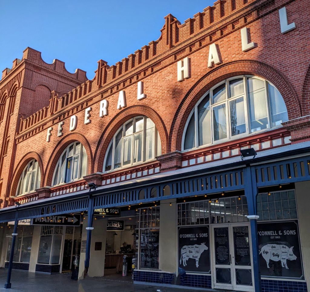
The Market is in a beautiful old building which is being expanded with a huge complex being built next to it.
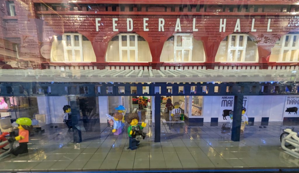
Inside, we found a Lego model of the Market, complete with little Lego workers and shoppers!
We returned to the train for a wonderful lunch and exciting entertainment in the lounge car!

Drag Bingo! A great performance!
May 6 It’s a Great Big Place… (Day 222)
…Full of Nothing But Space, and It’s My Happy Place!
You say your dog ran away,
And out here it can take 3 days.
I’ve heard every joke,
I’ve heard everything you say.
You think there’s not a lot goin’ on.
But look closer baby, you’re so wrong,
And that’s why you can stay so long,
When there’s not a lot goin’ on.
From the TV show “Corner Gas” set in Saskatchewan, Canada, just about as flat and expansive as the Nullabor Plain, but not as big!!
We woke up in the Nullabor…

At 6:21am we opened our blinds to the view on the bottom right! At 7:11am we repaired to the lounge car to wait for breakfast service, top right view. At 8:09am we waved to the lone person on the siding at Forrest, which looked like it consisted of a dirt airfield, power lines and no visible housing, maybe behind some trees in the distance, bottom left view. At 10:45am we crossed the WA/SA (Western Australia/South Australia) border.
After lunch at about 2:30 we stopped in the ghost town of Cook. Established in 1917 when the railway was built, it was a major center for track maintenance and locomotive and rolling stock repairs, and it supported a school and hospital. The town was effectively closed in 1997 when the Australian National Railways’ assets were sold to a private railway operating company and has a population of 4 now. Cook is the only scheduled stop on the Nullarbor Plain for our passenger train and has little other than curiosity value for us passengers strolling around while the train is replenished with water. We disembarked and strolled for about 45 minutes, learning the “Australian Wave”, flicking your hand across your face to scatter the flies buzzing around!
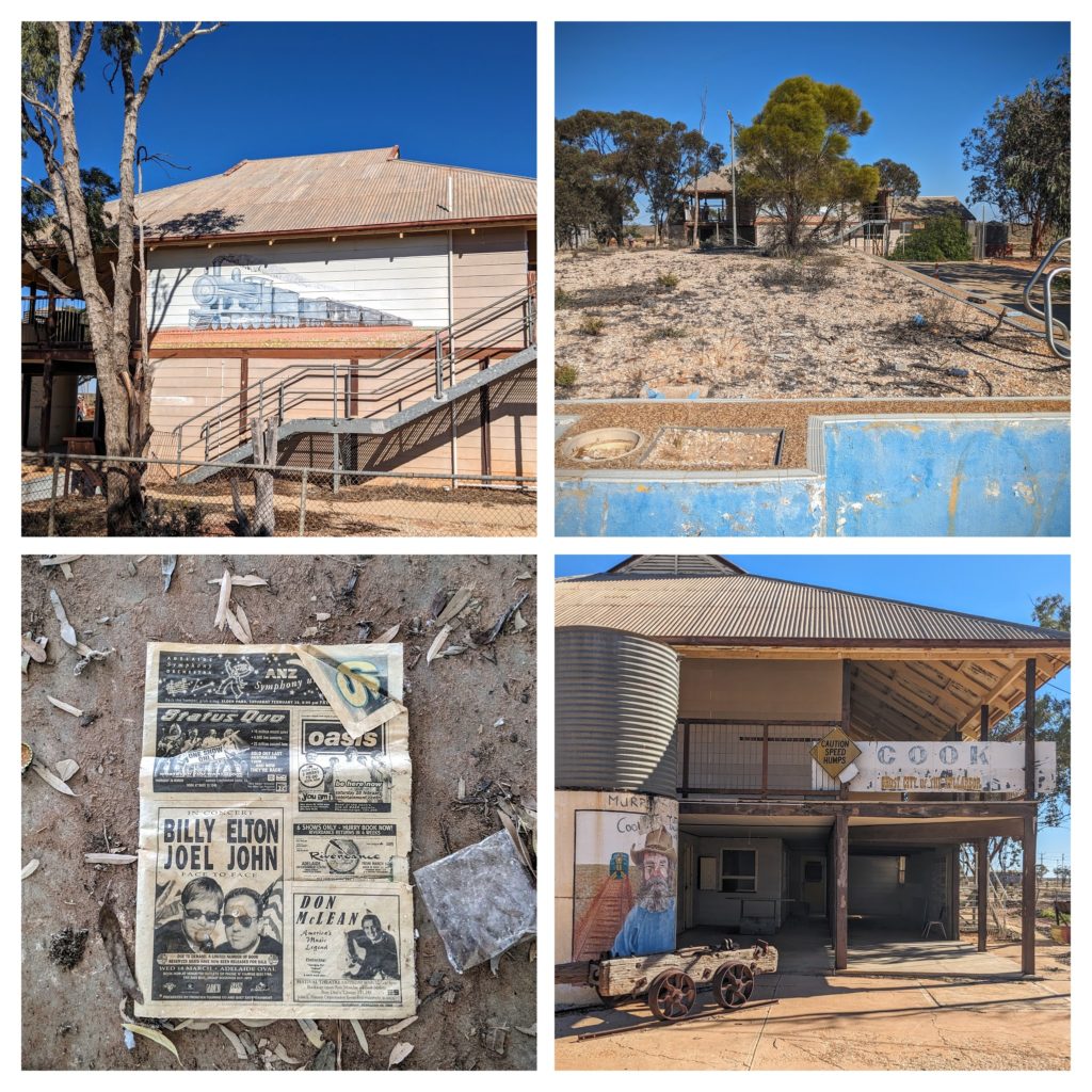
The largest building still standing is the old school with the now filled-in swimming pool out front!
A newspaper laying in the shade under the 2nd story deck dated from 1998 and advertised a concert with Elton John & Billy Joel for March 18 in Adelaide!
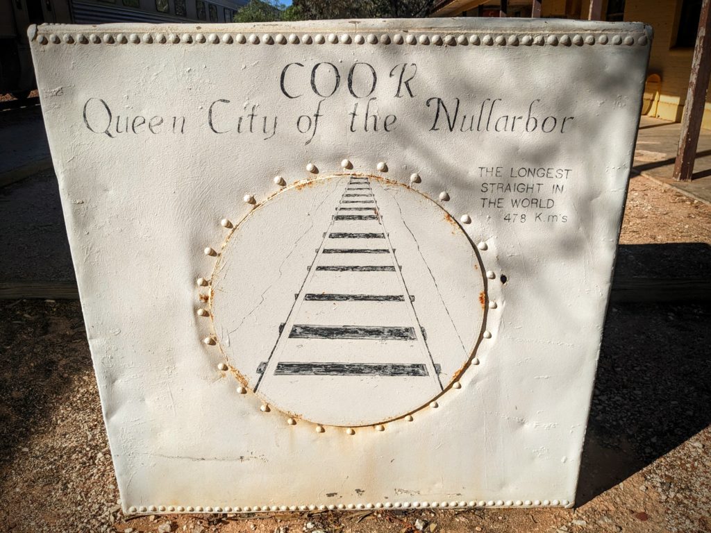
The railway line has the longest straight section of railway in the world (478 km; 297 mi)!

Robert had time to set up his drone and fly over the townsite to take a picture of the Indian Pacific in it’s entirety, dwarfed by the surrounding flat plain!
We boarded the train when the whistles blew and continued down the track and into the night, enjoying our second gourmet dinner and nightcaps in the lounge car!
May 5 All Aboard! (Day 221)
We were up very early, finishing up breakfast and last minute house cleaning before we packed the car and headed out to return it.

We saw our first urban kangaroos! And the first on the continent, this morning at sunrise on our way to turn in the rental car.
We caught the metro train from the airport to the central train station to board the Indian Pacific!

Our first sight of the train!
After a buffet-continental breakfast on the station platform, consisting of pastries, both sweet and savory, fruit, coffee or tea, and juice we were shown to our cabin to settle in.

We enjoyed our first glass of wine in our cabin as the train started moving through Perth!

We followed the Avon River out of the suburbs of Perth and even spotted areas with motorhomes and caravans camping along its banks.

In no time at all it seemed we were free of the urban/suburban boundary and traveling through the Western Australia Outback! We joined our fellow travelers in the lounge car to enjoy the view and meet new friends!
Our trip started at 10am and we were soon seated for lunch, the first of many gourmet meals! By sunset, around 5:30pm we were ready for our next meal, but our seating was at 6:15, oh well, time for another glass of wine!

Dinner is a 3 course affair, this is the main course. By the dessert course it was dark out!
As we all relaxed to digest our wonderful meal, at almost 10pm we made our first stop, Kalgoorlie, the iconic Western Australia (WA) goldmining boom town! Those of us choosing to take the tour, which lasts until midnight, boarded coaches and were whisked through the dark, quiet streets that echoed with the bustle of the goldmining boom of 1893! We disembarked our buses at the SuperPit, a huge hole in the ground that has been producing gold ore since the heady days of the boom. In 1989 the Kalgoorlie Consolidates Gold Mines was able to buy up many mining leases spread along the “Golden Mile” of lucrative ground, amalgamating them into one giant hole or SuperPit!

Since it was ‘a dark and stormy night’ with lightning in the distance, the view of the pit was underwhelming, so I took a picture of the signboard showing an aerial view of the pit! The huge trucks used to move the ore looked like tiny dots of light in the depths of the pit.
From the SuperPit we continued the tour to a museum based over an old mine, Hannans North Tourist Mine, Paddy Hannan being one of the miners that discovered the gold field here! We were entertained with a short play, which I didn’t understand much of, being delivered in ‘Australian slang’, or maybe an Irish-Australian accent!

The vignette of early Kalgoorlie townsite was the backdrop for the play.
The buses then returned through town, and took us along Hay street, THE most notorious Red Light District of Australia! The blurry picture of the ‘pink doors’ is the last brothel, no longer operating only recently! The Questa Casa was the oldest operating brothel in Australia! Apparently tours are conducted at 3pm daily, but there are no more after-dark services offered!
We were then deposited back at the station to board the train and climb into our beds for the first night of rocking and rolling along the rails!

The green line is the extent of travel today, from Perth to our first stop, Kalgoorlie. Overnight we will continue traveling east to reach our next stop, Cook, tomorrow!
May 4 Play in Perth (Day 220)
Our last full day in Perth was spent redistributing our packing for our upcoming 4 day train trip and then an afternoon walk with the family. It was another beautiful day in Perth, warm but with some clouds, the air cleaned by the recent rains, and a light breeze to keep us cool.

The favorite playground and swing!

Beautiful bougainvillea shows off Perth’s semi-tropical climate!
